Projects

Our Team has covered the map when it comes to Field Audits and Green Design.

All
Field Audits
GIS
Green Design
gallery-masonry-1-370x256

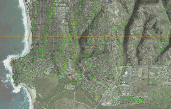
CITY OF SUNNYVALE - SEWER MASTER PLAN - GPS FIELD AUDIT

Field Audits

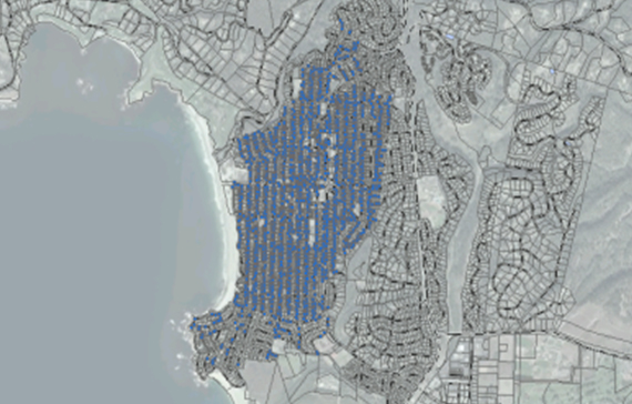
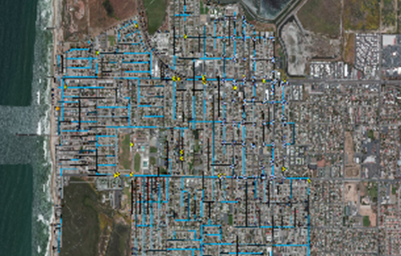
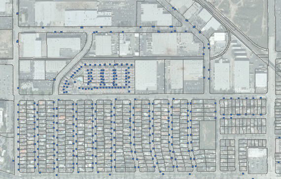
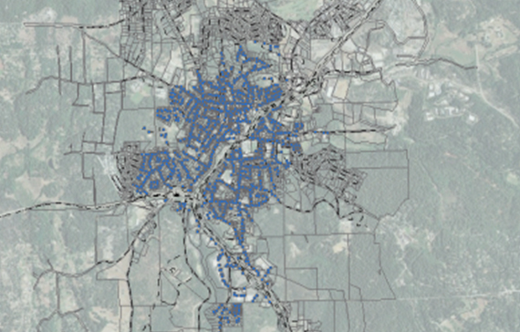
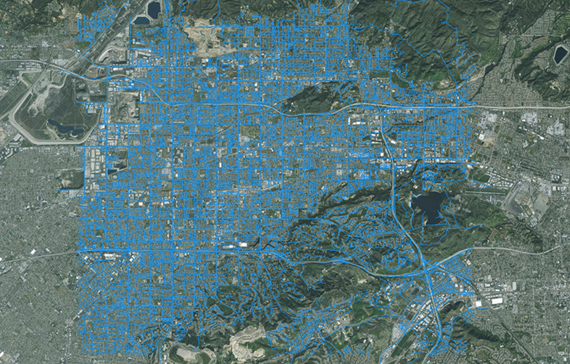
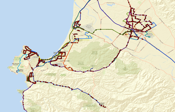
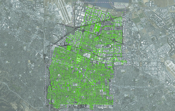
Storm Drain and Sewer Manhole GPS Field Audit - City of Sunnyvale - (August 2012) The City of Sunnyvale (“The City”) awarded Infrastructure Engineering Corporation (“IEC”) a Project to collect GPS locations of storm drain and sewer manholes throughout the city for a Storm Drain and Sewer Master Plan. GID converted CAD maps to GIS and created routes to field verify as-built and planning maps using high-resolution GPS. Consulting services were also conducted by GID for IEC to post processes GPS data and verify the accuracy and integrity of data collected during the project. GID mapped over 10,000 manholes within the City of Sunnyvale for the GIS Sewer Master Plan

poppies

MONTEREY PENINSULA REGIONAL PARK DISTRICT

GIS

Our firm developed the Natural Resource Management GIS for the Monterey Peninsula Regional Park District (MPRPD); a land use planning and conservation tool for preserving open space. The Visitor Education Guide (VEG) and the MPRPD Explore! linked in the MPRPD Let’s Go Outdoors (LGO) mobile app named “LGO on the GO!” The MPRPD Exlplore! allows historical information to be added to the MPRPD GIS for storytelling and educational narrative in the Visitors Center and throughout the parks.

gallery-masonry-6-370x464

BIG SUR FIRE WEB GIS

GIS

Prior to the devastating fires of 2020 in California, our team built and developed many pre-fire plans using Web GIS including the Big Sur Fire (BSF) and Woodside Fire Protection District (WFPD) GIS Hubs. The HUBs are used for Wildland Urban Interface (WUI) inspection, pre-fire planning, and asset management. Other fire related projects includes the Fire Fuels Mapping Project (FFMP) for the California State Parks and the Monterey County Resource Conservation District (MCRCD) in 2019. The RCD FFMP is a historical library of information that is used in conjunction with strategic fire and fuels planning projects across the County of Monterey.

gallery-masonry-2-370x464

SANTA LUCIA PRESERVE - COMMUNITY SERVICE DISTRICT - GIS FIELD AUDIT

Field Audits

The Santa Lucia Preserve - Community Service District - Carmel Valley - (April 2016) The Santa Lucia Preserve (“SLP”) - Community Service District hired Turf Image to create a Wastewater and Septic, Sewer and Drainage GIS Geodatabase. The current GIS was used to summarize field data collected by the SLP staff. Information was used to create a basemap for map book production. The GIS is currently used to activity design and update the infrastructure for the Community Service District.

gallery-masonry-3-370x256

PALO CORONA REGIONAL PARK - GIS GENERAL PLAN

Green Design

A landmark deal was announced today wherein 140 acres of Rancho Cañada Golf Club will be acquired and turned over to the Monterey Peninsula Regional Park District, providing greater public access to both the Carmel River and Palo Corona Regional Park. The pending purchase concerns Rancho Cañada's eastern golf course; the western course is also slated for closure, and is the site for a proposed housing development brought forward by Alan Williams and Clint Eastwood. The acquisition will create a key north-south wildlife corridor connecting the Santa Lucia Range to Jacks Peak and beyond, and will open up new corridors of public access as well: When the plan is fully realized, it could be possible to mountain bike all the way from Jacks Peak to Point Lobos.

BayonetBlackHorse

BAYONET & BLACK HORSE GOLF COURSE - SEASIDE RESORT DEVELOPMENT

Green Design

GPS Mapping - Seaside Resort Development - Bayonet & Black Horse Golf Course (August 2007) The Seaside Resort Development Company (Bayonet & Black Horse Golf Courses) contracted Turf Image to collect GPS data for fairways, tees, bunkers, and cart paths prior to construction to estimate the cost of materials. Our team worked with world renowned golf course designers to create a GIS mapping solution to show what the course would look like during the flagging stages of design. Imagery, LiDAR, GIS and GPS data was used to create Turf Image products to lower cost of chemicals and water application during the developmental stages.

CAWD

CARMEL AREA WASTEWATER DISTRICT - GPS FIELD AUDIT

Field Audits

The Carmel Area Wastewater District (“CAWD”) awarded a contract to Turf Image, Inc. (“Turf Image”) to collect GPS locations of sewer manholes throughout the district for a GIS Sewer Master Plan update. Turf Image converted CAD maps to GIS and created routes to field verify as-built and planning maps using high-resolution GPS. Consulting services were also conducted by Turf Image for CAWD to create billing and main updates using GIS and GPS. A geometric network was produced and used to build a GIS System for the CAWD.

IRWD

IRVINE RANCH WATER DISTRICT - GPS FIELD AUDIT - WATER METERS

Field Audits

Irvine Ranch Water District (“IRWD”) awarded DCSE, Inc (“DCSE”) a Project to collect GPS locations, of its over 100,000 service meters, for water, recycled water and irrigation. The scope involved creating routes as well as linking service meters with parcels. DCSE started with route analyses and generated efficient routes, using service villages and books within them. DCSE field crew used Trimble GeoXH and a DCSE-designed ArcPad application to link parcels with meters, so as to integrate a wide variety of consumer information with GIS. This project was showcased at the ESRI User Conference this year (2011) in San Diego CA. Green Infrastructure Design (“GID”) signed a contract with DCSE to create efficient survey routes, conduct GPS surveys using the routes, link GPS data to assessor parcels, and verify the account database of over 44,000 service meter using high-resolution Trimble GPS units and Zephyr antennas. GIS and GPS consulting services were also conducted by Turf Image for DCSE to post processes GPS data and field verify the accuracy and integrity of data collected during the project

PARKS

SOBERANES FIRE AND CARMEL FIRE DAMAGE AND EROSION CONTROL

Green Design

The Santa Lucia Conservancy (“SLC”) and the Monterey Regional Park District (MPRPD) hired GID to create a basemap for the Soberanes Fire and Erosion Control Efforts. The main objective of the project was to map the fire lines and damages created by the wildfire. The goal of the project was to GPS map the fire lines and define four (4) different restoration treatments. The four (4) different restoration treatments were defined using the slope, the vegetation and the soils of the area effected to best control erosion and restore habitat.

CalAm_LA

CALIFORNIA AMERICAN WATER - LOS ANGLES SYSTEMS - GPS FIELD AUDITS

Field Audits

Valve and Hydrant GPS Field Audit - Los Angles Systems - (January 2015) California American Water (“Cal Am”) awarded a contract to Green Infrastructure Design (“GID”) to collect GPS locations of street valves and fire hydrants within the Cites of San Ramon, Baldwin Hills and Duarte, CA. The goal of the project was to verify location of assets and compile information for CMMS. Data collected will be used to create a geometric network and map books for CAW staff. Historical information such as as-builts and valve cards were used to confirm field locations. Founded in 1886, American Water is the largest and most geographically diverse publicly traded U.S. water and wastewater utility company. Turf Image mapped over 20,000 assets in the greater Los Angles and Ventura areas for California American Water and continues to offer GIS and GPS Mapping Solutions.

CalAm_Monterey

MONTEREY & CARMEL FIELD AUDIT OF WATER METERS

Field Audits

California American Water (“Cal Am”) awarded a contract to Turf Image, Inc. (“Turf Image”) to collect GPS locations of street valves and fire hydrants within the Cities of Carmel-by-the-Sea, CA. The goal of the project was to verify location of assets and compile information for CMMS. Data collected will be used to create a geometric network and map books for CAW staff. Historical information such as as-builts and valve cards were used to confirm field locations.

CalAm_SAC

SACRAMENTO SYSTEMS GIS FIELD AUDIT

Field Audits

Water Meter GPS Field Audit - Sacramento Systems - California American Water (September 2013) California American Water (“Cal Am”) awarded a contract to Turf Image, Inc. (“Turf Image”) to collect GPS locations of commercial service meters throughout the Sacramento Systems. The scope involved converted CAD drawings, creating routes from existing books, converting account databases into shapefile format, and conducting a GPS field audit while verifying account information and tying in assessor’s parcel information and cross streets.

CalAm_SD

SAN DEIGO WATER SYSTEM FIELD AUDIT

Field Audits

Street Valve and Hydrant GPS Field Audit - San Diego System - California American Water (January 2014) California American Water (“Cal Am”) awarded a contract to Turf Image, Inc. (“Turf Image”) to collect GPS locations of street valves and fire hydrants within the Cities of San Diego, Coronado and Imperial Beach, CA. The goal of the project was to verify location of assets and compile information for CMMS. Data collected will be used to create a geometric network and map books for CAW staff. Historical information such as as-builts and valve cards were used to confirm field locations.

Torrance

CITY OF TORRANCE - GPD FIELD AUDIT WATER METERS

Field Audits

Water Meter GPS Field Audit - City of Torrance, CA - Global Water Resources (November 2010) Global Water Resources, Inc. (“Global Water”) and the City of Torrance, California (“Torrance” or the “City”) announced today that they have signed an agreement to implement all three product offerings of Global Water’s FATHOM™ Utility-to-Utility (U2U™) Solutions. The Torrance contract calls for the replacement of approximately 28,000 manually read water meters with FATHOM’s Advanced Metering Infrastructure (“AMI”) and the provision of customer service and billing for 32,000 water and wastewater customers throughout the City. Turf Image, Inc. (“Turf Image”) signed an agreement with Global Water to conduct a Full-System Water Meter Field Audit of all 28,000 service meters to provide location and conditions to be replaced with AMI registers. GIS and GPS consulting services were conducted by Turf Image to create ArcGIS shapefiles and layouts, field map books, and GPS data collection to field verify the account database using high-resolution Trimble GPS units and Zephyr antennas.

GrassValley

CITY OF GRASS VALLEY - GPS FIELD AUDIT WATER METERS

Field Audits

Water Meter GPS Field Audit - City of Grass Valley, CA - Global Water Resources (April 2011) Global Water Resources, Inc. (“Global Water”) and the City of Grass Valley, California (“Grass Valley” or the “City”) announced today that they have signed an agreement to implement all three product offerings of Global Water’s FATHOM™ Utility-to-Utility (U2U™) Solutions. The Grass Valley contract calls for the replacement of approximately 2,400 manually read water meters with FATHOM’s Advanced Metering Infrastructure (“AMI”) and the provision of customer service and billing for 4,200 water and wastewater customers throughout the City. Turf Image, Inc. (“Turf Image”) signed an agreement with Global Water to conduct a Full-System Water Meter Field Audit of all 2,400 service meters to provide location and conditions to be replaced with AMI registers. GIS and GPS consulting services were conducted by Turf Image to create ArcGIS shapefiles and layouts, field map books, and GPS data collection to field verify the account database using high-resolution Trimble GPS units and Zephyr antennas.

Covina

CITY OF COVINA - GPS FIELD AUDIT WATER METERS

Field Audits

Water Meter GPS Field Audit - City of Covina, CA - Global Water Resources (April 2010) Global Water Resources, Inc. (“Global Water”) and the City of Covina, California (“Covina” or the “City”) announced today that they have entered an agreement for utility-to-utility services providing an integrated billing, remittance, collections and customer information system (“CIS”) employing Global Water’s FATHOM™ Utility-to-Utility (“U2U™”) Solutions platform. Turf Image, Inc. (“Turf Image”) signed an agreement with Global Water to conduct a Full-System Water Meter Field Audit of all 8,200 service meters to provide location and conditions to be replaced with AMI registers. GIS and GPS consulting services were conducted by Turf Image to create ArcGIS shapefiles and layouts, field map books, and GPS data collection to field verify the account database using high-resolution Trimble GPS units and Zephyr antennas.

QuailMeadows

QUAIL MEADOWS HIKING TRAIL MAP

GREEN DESIGN

Quail Meadows - Hiking and Emergency Road Map - (September 2015) The Quail Meadows Homeowners Association contracted Turf Image to GPS map the trails at Quail Meadows to produce a trail map display and brochure. The GPS and GIS data collected and created was also used to create an Emergency Management plan for local residents.

MissionTrails

MISSION TRAILS NATURE PRESERVE

GREEN DESIGN

Mission Trails Nature Preserve - Biological Assessment - City of Carmel-by-the-Sea -(August 2015) The City of Carmel-by-the-Sea (“The City”) awarded a contract to Turf Image, Inc. (“Turf Image”) to prepare maps for the Baseline Biological Assessment for the Mission Trails Nature Preserve. Working with Nicole Nedeff of Consulting Ecologist to create a mobile mapping application using Avenza PDF maps to collect biological information for her report. The Biological Assessment report will be used to create a general plan and trail maps for the city of Carmel-by-the-Sea.

ClearChannel

CLEAR CHANNEL - BUS STOP POWER SURVEY

GIS

Clear Channel Communication - GIS & GPS Mapping - Bus Stop Power Survey (March 2008) Clear Channel Communication contracted Gold Coast Electric to conduct a power supply survey for over 1,000 bus stops in San Francisco, CA. Turf Image was contracted to map bus stop locations along with the power source. Our team used geocoded route information and GPS to highlight each route with bus stop locations. The geodatabase serves as a base map to illustrate what types of power each bus stop uses to better decide what type of advertisement clear channel may offer at each stop.

ceus-ssc

CENTRAL AND EASTERN UNITED STATE SEISMIC SOURCE CHARACTERIZATION FOR NUCLEAR FACILITIES (CEUS-SSC)

GIS

Central and Eastern United States Seismic Source Characterization for Nuclear Facilities (CEUS-SSC) The Central and Eastern United States Seismic Source Characterization for Nuclear Facilities (CEUS-SSC) Project was conducted from April 2008 to December 2011 to provide the nuclear industry a new, regional seismic source model for use in conducting probabilistic seismic hazard analyses (PSHAs) for nuclear facilities. PSHA is used as a method for accounting for uncertainty in seismic design and in calculating seismic risk. Turf Image was contracted by Lettis Consultants International, Inc. to create the Central and Eastern United States Seismic Source Characterization for Nuclear Facilities (CEUS-SSC) Web Portal to share GIS information from the project. NRC contract number: NCR-04-09-144, DOE funding Provided in Award DE-FG07-08ID14908 WWW.CEUS-SSC.COM

PinePitchCanker

MONTEREY PINE FOREST MAPPING FOR FIRE PREVENTION

GREEN DESIGN

Monterey Pine Forest Remote Sensing Project - GIS and GPS Mapping(May 2002) Utilizing Geographic Information Systems (GIS) and remote sensing technologies, the Spatial Information, Visualization and Analysis (SIVA) Center of the California State University at Monterey Bay (CSUMB) has been conducting research and mapping of the spread of pitch canker infestation of native Monterey pines (Pinus radiata) and Bishop pines (P. muricata) in Monterey County. In collaboration with the California Department of Parks and Recreation, the Asilomar State Beach & Conference Grounds (Asilomar State Park) was chosen as the first training (pilot study) site to collect information about pitch canker infestation

MST

MONTEREY-SALINAS TRANSIT - RIDERSHIP GIS AND ROUTE MAPPING

GIS

Transit Mapping and Geodatabase Project - Monterey-Salinas Transit (April 2005) The Monterey-Salinas Transit contracted Turf Image to create a GIS for route analysis and stop ridership of the mass transit system. The Monterey-Salinas Transit operates 37 routes and serves an estimated 352,000 population across a 280 square-mile area of Monterey County and Southern Santa Cruz County. Our team used street data and GPS data to highlight each route with bus stop locations. The geodatabase serves as a base map to illustrate ridership values for each stop based on riders boarding and existing buses. Vector data was created and buffered to calculate the overall service area of the Monterey Salinas Transit.

SVBF

SHENANDOAH VALLEY BATTLEFIELDS FOUNDATION - GIS MAPPING

GIS

Geodatabase Project - Shenandoah Valley Battlefields Foundation (December 2005) Turf Image assisted The Shenandoah Valley Battlefield Foundation with creating a GIS basemap to help their organization goals. The Shenandoah Valley Battlefield Foundation partners with landowners, local governments, and others to protect the Valley’s battlefields and historic character. The Foundation focuses on the 21,000 acres of land retaining historic integrity on the ten legislated battlefields. This is done collaboratively through the purchase of land and conservation easements from willing sellers. The Foundation also works with local governments to improve the planning and preservation protections that will help to ensure the survival of the battlefields.

LCWA

LAKE COUNTY WATER AUTHORITY (LCWA) - HISTORICAL AERIALS 1942-2000 LAND USE CHANGE

GIS

GIS Historical Aerial Project Archive 1942-2000 - Lake County Water Authority (May 2006) Lake County Water Authority (“LCWA”) (FL) awarded a contract to Turf Image, Inc. (“Turf Image”) to scan, digitize, georeference, and convert historical aerials for incorporation into the LCWA GIS. The project area encompassed the entire Lake County, FL an area of about 1,156 square miles in Central Florida. Our Geospatial team scanned, georeference, orthorectified, color contrasted, mosaiced, and compressed over 2,000 aerial Mylar sheets for use in a GIS.

HabitatForHumanity

SILICON VALLEY HABITAT FOR HUMANITY - GIS REAL ESTATE MAPPING

GIS

GIS Mapping and Database Creation - Silicon Valley Habitat for Humanity - (February 2007) The Silicon Valley Habitat for Humanity Organization recently requested Turf Image to propose a cost schedule to create a Geographic Information System (GIS). The GIS system would help the organization make more informed decisions and help locate and acquire land for Silicon Valley Habitat for Humanity to develop.

PCRP

PALO CORONA REGIONAL PARK - GIS GENERAL PLAN

Green Design

Palo Corona Regional Park - GIS Mapping & Mobile Maps Palo Corona Regional Park is one of Central Coast California’s most significant undeveloped open spaces. In the largest land conservation project in Monterey county history, The Nature Conservancy, The Big Sur Land Trust, State of California (through several of its agencies), and Monterey Peninsula Regional Park District partnered to acquire the 10,000-acre Palo Corona Ranch. The acquisition was finalized in 2004. The 10,000-acre ranch was then divided between the State Department of Fish & Game and The Park District to be protected as public conservation and Parkland in perpetuity. The State Department of Fish & Game added the southern 5,500 acres of the former ranch to its existing 640-acre Joshua Creek Ecological Preserve (Preserve). The Park District created the new Palo Corona Regional Park (Park) with the northern 4,350 acres of the former ranch

JacksPeak

JACKS PEAK COUNTY PARK - GIS GENERAL PLAN

GREEN DESIGN

Jacks Peak - GIS Mapping & Mobile Maps Jacks Peak is forested with the largest remaining native Monterey pine grove in the world. (Only three other native stands exist: near Cambria, Santa Cruz and on Guadalupe Island about 200 miles off the coast of Baja California.) Though the fast-growing Monterey pine has been successfully transplanted across California and around the world, there is something special about visiting the conifer in its native habitat. Jacks Peak and Jacks Peak County Park honor Scottish immigrant David Jacks, successful 19th-Century businessman, dairy owner and land speculator. Jacks is best remembered today for Monterey Jack cheese, the only native California cheese.

Green Infrastructure Design